LOUISVILLE, Ky. — We are tracking rain and snow across Kentuckiana!
Rain will start to transition to snow early Saturday mroning.
For the rest of Saturday, we forecast cloudy skies and mostly dry conditions, although a few flurries or drizzle can’t be ruled out. Additional light, cold rain showers will quickly rotate through Kentuckiana early Saturday night.
Rain, snow, or both?
This answer highly depends on where you live in the region. We’ve been devoid of snowfall in much of Kentuckiana recently. In fact, the last time Louisville saw at least 1” of snowfall in a single weather event was Jan. 22, 2023!
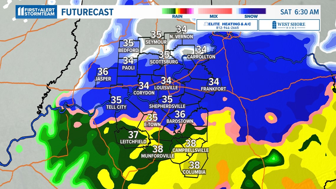
We do believe snow will fall in areas mostly along and north of I-64 before sunrise Saturday. Southern Indiana has the greatest opportunity of not just seeing snow, but also possible snow accumulation.
If you live south of I-64, it’s most likely you’ll only see cold rain with temperatures in the 30s. Snow might mix in with rain but expect mostly liquid precipitation. Any accumulations would be under one inch.

Temperatures will play a very important role when it comes to precipitation type and possibility of accumulation.
Upper level temperatures are largely below freezing, which will support snow formation and snowfall. Near-surface temperatures, however, will be on either side of freezing. Those temperatures will play a huge factor in whether or not you experience cold rain or a rain-snow mix.
As of now, Louisville proper will likely sit near the rain/snow transition line. We currently forecast the city to stay above freezing but still see a slushy rain-snow mix in the pre-sunrise hours Saturday.
With ground and road temperatures still being relatively warm, it’ll be difficult for snow to accumulate. However, if snow falls hard enough it could overcome these warm temperatures and stick, but most likely on grassy or elevated surfaces. This is especially true for southern Indiana.

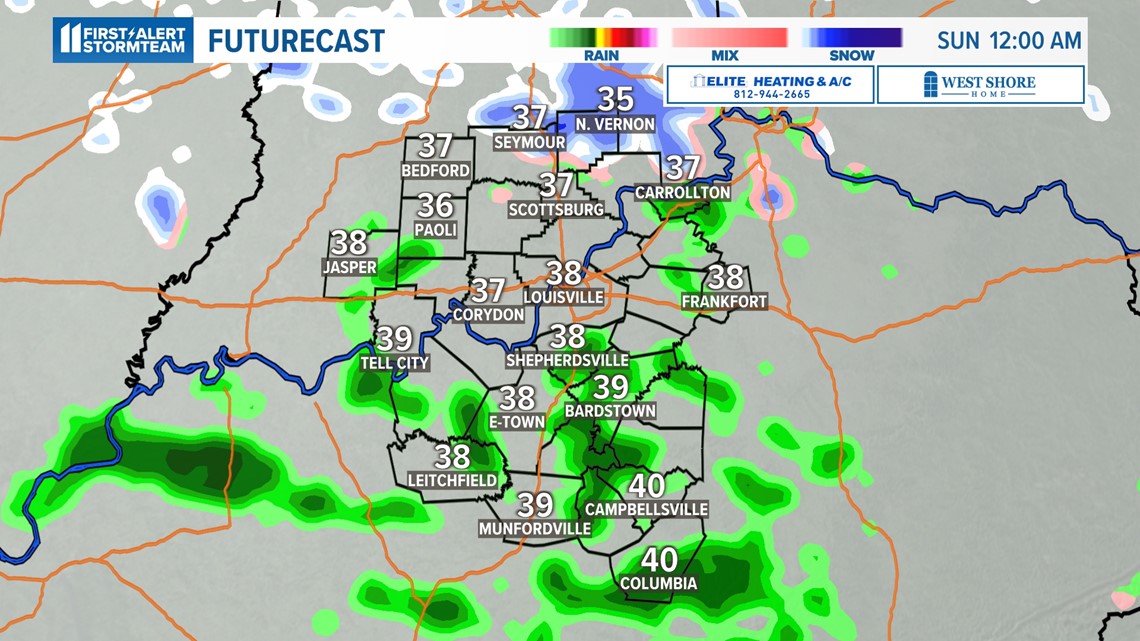
If snow accumulates north of I-64, it would probably be short lived. As the storm travels north, rain will gradually take over most of the area. This would likely melt anything that accumulated on the ground.
How much snow or rain?
This is going to be a relatively quick system, so totals for both should be relatively light. For snowfall, expect less than one inch in southern Indiana where snow is most likely to accumulate.
Isolated communities may see a little more, but that will depend on snowfall intensity. Greater chances of snow accumulation/amounts will come in northern Kentucky and along the I-75 corridor heading into Ohio.

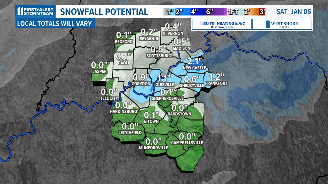
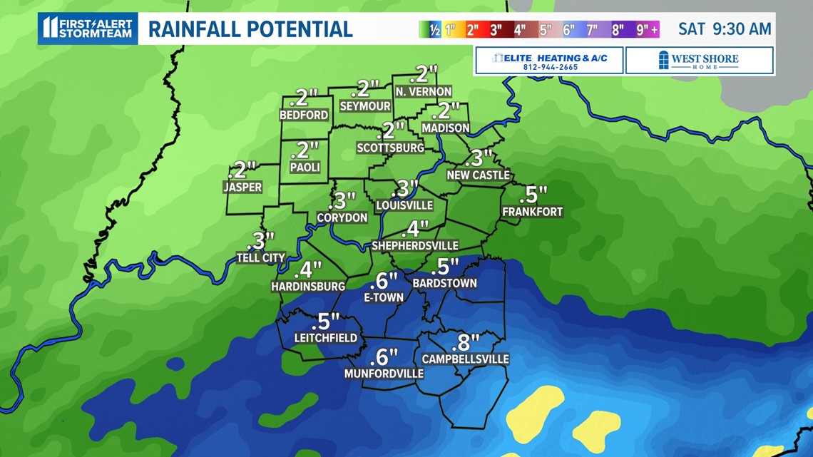
As for rainfall totals, generally half an inch or less is expected, but perhaps some higher totals south of I-64 where more rain than snow is anticipated.

Winter weather could return next week
This isn’t the only storm system we’re tracking.
Another one is set to arrive Tuesday next week and likely be all rain, perhaps a soaking rain which is sorely needed. That may result in some snow on the backside of the storm Wednesday.
After that, we’ll be watching another storm system for the weekend of the 13th & 14th of January.
Meteorologist Alden German
Facebook: Facebook.com/AldenGermanWX | Twitter: @WXAlden
Make it easy to keep up-to-date with more stories like this. Download the WHAS11 News app now. For Apple or Android users.
Have a news tip? Email assign@whas11.com, visit our Facebook page or Twitter feed.