LOUISVILLE, Ky. — 8:40 p.m. | A Tornado Watch is in effect until 1:00am for Adair, Breckinridge, Bullitt, Grayson, Green, Hardin, Hart, Larue, Marion, Nelson, Taylor and Washington Counties. A tornado watch means conditions are favorable for the development of severe storms, capable of producing tornadoes. Have a plan and be prepared to seek shelter if a warning is issued for your area.
8:30 p.m. | Tornado warning expires for Adair County.
7:50 p.m. | A Tornado Warning is in effect until 8:30pm for Adair County.
Severe Thunderstorm Warning for East central Butler County in south central Kentucky... South central Grayson County in central Kentucky... Edmonson County in south central Kentucky until 8:30 p.m
Flash Flood Warning for... Casey County in central Kentucky... Northeastern Adair County in south central Kentucky until 11:15 p.m.
Flash Flood Warning for Larue County in central Kentucky until 10:45 p.m.
Flash Flood Warning for Southern Hart, Northern Warren, Barren, Edmonson, Green and Taylor Counties until 10:15 p.m.
Flash Flood Warning for Hart County in central Kentucky until 9:00 p.m.
Flash Flood Warning for... Central Grayson County in central Kentucky... Southwestern Hardin County in central Kentucky... Until 930 PM ED
A Tornado Watch is in effect until 1:00am for Breckinridge county until 1:00 a.m.
6:30 p.m | Tornado warnings expire. Severe weather threat remains in place for several counties in Kentuckiana.
5:35 p.m. | Tornado warning issued for Grayson County, Ky. No damage reported.
More counties under tornado warning: Northwestern Hart County in central Kentucky. Northeastern Edmonson County in south central Kentucky.
5:57 p.m. Severe thunderstorm capable of producing a tornado was located just west of Ollie, moving east at 35 mph. Locations impacted include... Munfordville, Bonnieville, Ollie, Leitchfield Crossing, Bee, Macon, Rowletts, Logsdon Valley, Lines Mill and Big Windy.
A Severe Thunderstorm Warning is in effect until 6:30pm for the Kentucky counties of Grayson & Hardin. Seek shelter at this time. Stay inside until the warning is cancelled and the threat is over. Winds in excess of 60 mph are possible. Damage to trees, powerlines, and property is possible.
A Tornado Watch is in effect until 1:00am for the Kentucky counties of Adair, Breckinridge, Bullitt, Grayson, Green, Hardin, Hart, Larue, Marion, Nelson, Taylor and Washington. A tornado watch means conditions are favorable for the development of severe storms, capable of producing tornadoes. Have a plan and be prepared to seek shelter if a warning is issued for your area.
Stay alert to the forecasts online and on WHAS11 as we head into an active weather afternoon that could bring a strong storm.
Currently, this Kentucky county is under a tornado warning:
- Grayson
Currently, these Kentucky counties are under a tornado watch:
- Breckenridge
- Grayson
- Hardin
- Hart
- Meade
In Indiana the following counties are under a tornado watch:
- Crawford
- Dubois
- Orange
- Perry
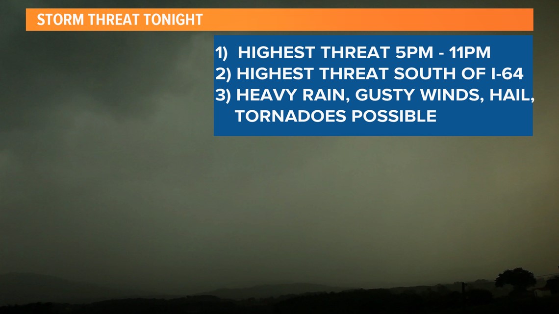
Here's the timeline for the possibility of severe weather:
The WHAS11 Weather Team says Thursday afternoon and evening is when we could see severe weather. Strong storms could impact Kentuckiana between 5 p.m. and 11:00 p.m. this evening.

Download the WHAS11 News app now for weather alerts and updates.
Everyone across the area needs to be prepared. The SPC has upgraded our threats to levels 2 and 3 out of 5 on their severe weather scale.

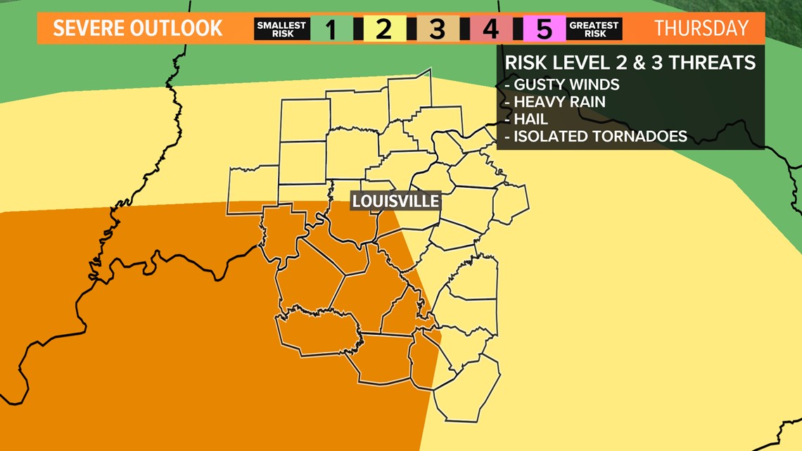
The areas in the darkest orange color on the above graphic are included in the highest risk spot, but that doesn't mean areas outside of that are in the clear. We all need to stay alert to forecasts updates throughout the middle of the day ahead of this system. Things look like they will wind down around midnight.
Download the WHAS11 News app now for weather alerts and updates.