
LOUISVILLE, Ky. — In our last blog we discussed the supercell: what it is, its components, and unique features associated with it. That was more of a broad stroke on those storms and not every supercell will look the same. There are three primary classes of these storms and two supplementary ones.
Three classes of supercells:
- Low Precipitation (LP)
- Classic (CL)
- High Precipitation (HP)
Supplementary types:
- Mini
- Left-moving (anticyclonic)
RELATED: Anatomy of a storm: Supercells
Low Precipitation (LP) Supercells
As the name should imply LPs are characterized by their lack of precipitation. It’s not that they have no rain, just little of it. LPs lack for rain because the environment they form in lacks for moisture. They are generally rare but provide a good look at their structure. In an LP supercell, the updraft is the dominant mechanism with little precipitation reaching the ground. The shaft of precipitation that does reach the ground is often translucent or transparent. Remember that it's rain-cooled air that primarily fuels the downdraft. The little rain in an LP means their downdrafts are weak and outflows have a harder time developing, making it difficult for new storms to develop from it. A lot of the precipitation is carried downwind by winds in the middle-and-upper level parts of the storm.
Large hail (such as baseball-sized) can be found with LPs because the updraft is so dominant and there isn't enough water to counteract its intense rising motion. This allows ample time for hail to develop. A thin rain shaft in a LP might actually contain mostly hail.
Tornadoes are not as common in LP supercells due to the lack of rear-flank and forward-flank downdrafts (RFD/FFD). If a tornado does form, they are weak. Rotation in the lower levels of the storm, as well as the iconic hook echo often seen with supercells, is also rare because of the lack of downdrafts.
LPs are often found in areas that have poor access to abundant moisture, such as the High Plains near a dry line, or even as far west as California.

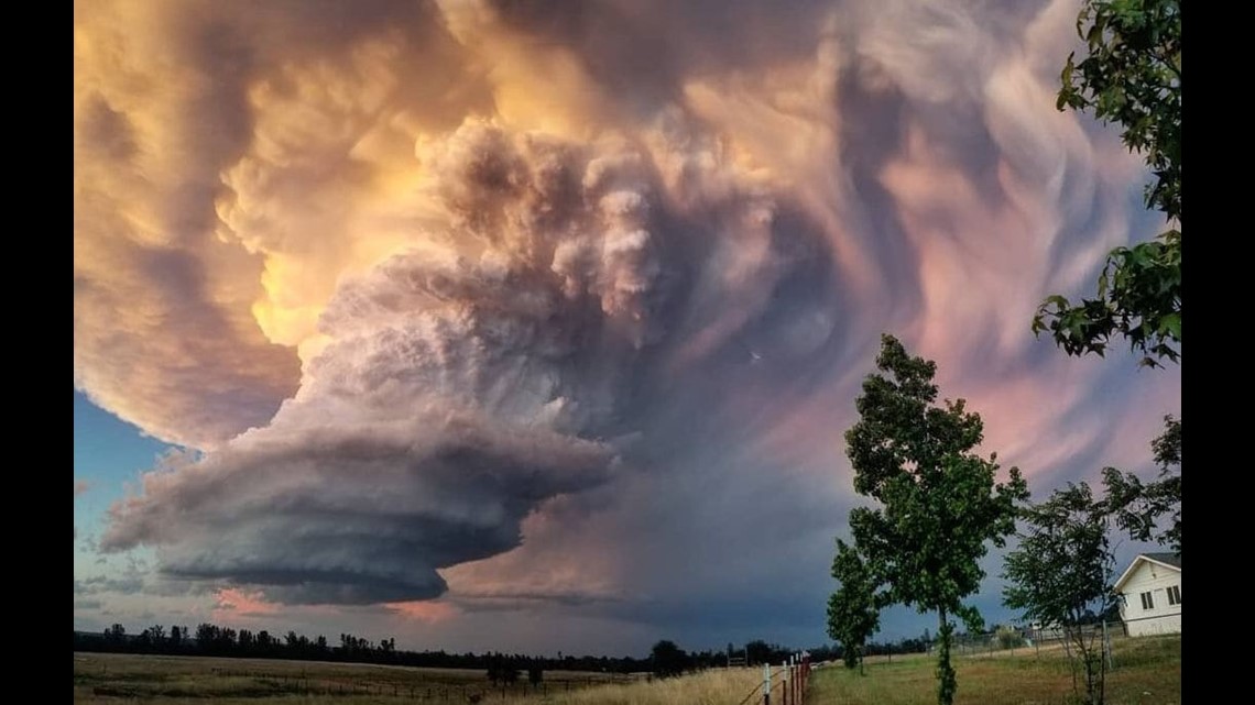
Classic (CL) Supercells
The textbook example of a supercell, classics are a healthy version of LP. They contain more precipitation and can form healthy downdrafts which aid in producing outflows that can keep the storm alive or later form new storms. The environment of a classic supercell has more moisture than its LP counterpart. Hail is common in classic supercells, and the iconic radar signatures such as hook echo, inflow notch, and mesocyclone (the rotating updraft) are now evident.

Speaking of mesocyclone, these storms have an easier time rotating because they have an RFD of significance. As the RFD reaches the surface it can create an outflow which is more easily re-ingested by the updraft, allowing for better rotation. Winds in the middle-and-upper levels are not quite as strong, so precipitation is less likely to be carried as far away as an LP.
Classic supercells are responsible for most long-track tornadoes and are particularly adept at cycling to produce new tornadoes later in its life. “Cycling” simply means that the storm briefly weakens, likely loses its tornado, then reorganizing to a point where it can once more drop a twister. An example of a classic supercell is the long-lived beast on April 22, 2020 which started in southeast Texas north of Houston, crossed into Louisiana where it traversed the entire state into Mississippi! That’s one storm producing multiple tornadoes for hundreds of miles! Below is a video of its lifespan.
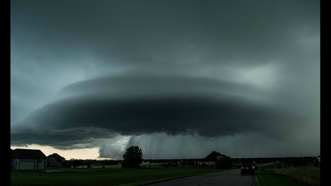
High Precipitation (HP) Supercell
If there’s a low precipitation supercell, it stands to reason that there’s a high precipitation one too. HP is the most common supercell. Their environment features much more moisture than CL or LP, but that’s not always necessary. They're most frequently found in the Deep South due to its close access to rich tropical moisture from the Gulf of Mexico. Rain isn’t carried as far away from the updraft, which means moisture can be “reabsorbed” by the storm and improve how well precipitation is created.
Since downdrafts come from rain-cooled air, HP supercells often have very intense downdrafts. These produce strong outflows which help to feed air into the storm so it can continue to thrive. Since rain is closer to the updraft, it can wrap around the mesocyclone creating the iconic hook echo.
An RFD is present, and if strong enough, its outflow can form the flanking line which is connected to the hook as a southern appendage. That flanking line can sometimes produce rain itself. Not all HPs are born as HPs. CL and less often LP can evolve into an HP if it’s near other storms that can feed into it, or if it merges with another storm.

High precipitation supercells can be very dangerous. They’re often long lived due to their strong updraft. The intense rainfall can produce localized areas of flash flooding, particularly if the cell is slow moving. Perhaps the most dangerous aspect of a tornadic HP supercell is its ability to completely obscure a tornado which is known as rain-wrapping.
Rain-wrapped tornadoes are particularly dangerous because a curtain of rain covering it up can make it difficult – if not impossible – to see and track from the ground. Sometimes it can even hide some of the basic hook features on radar. Meteorologists must be especially acute to this and looking at other radar data to detect a twister. They can also create an optical illusion. Often the thick curtain of rain gives the appearance of being a monstrous tornado when it’s actually hidden within it.
Supplementary Types
Mini Supercells
As the name implies, supercells can be quite small, but still strong. There is little structural difference between mini supercells and their larger counterpart, but minis are not as tall, and their mesocyclone is narrower. Giant hail is less likely because the updraft isn’t as tall or powerful, so it’s unable to carry rain and hail deep into the zone that hail typically grows in.
Radar often does a poor job at sampling mini supercells. Their small circulations make it difficult enough, but the rotation is often in the lower atmosphere. If the storm is far away from radar, these small circulations can be completely missed because the radar is looking far above it. Minis can be tornadic even though radar makes them see “innocent.”
Left-Moving (LM) Supercells
Left-moving supercells (also known as ‘left-movers’) are supercells that rotate clockwise – known as anticyclonic – and are the result of one storm splitting into two. It mirrors its right-moving counterpart. They very rarely produce tornadoes despite their ability to rotate, and they have a distinct trait of laying down large swaths of large hail. It’s poorly understood why left-movers are so good at producing hail. LMs are overall weaker than their right-moving twin because the environment they move into is not favorable for storm longevity.
--
That was quite a bit of information, but hopefully now you see that not every supercell storm is the same. There are many different varieties with different characteristics with their own risks. While some are stronger than others, all should be respected for their amazing structure and power.
Meteorologist Alden German
Facebook: Facebook.com/AldenGermanWX | Twitter: @WXAlden