LOUISVILLE, Ky. — We’re approaching another weekend, and that means another round of heavy rain through the area. This storm has been a long time coming; we’ve been forecasting this heavy rain event since late last week!
Forecast at-a-glance:
- Cloudy, breezy, and mild tonight
- Scattered showers likely for southern Indiana after midnight
- Scattered rain likely for Friday – wettest in Indiana
- Potential for severe weather and flooding Saturday
- It’ll be windy Friday and Saturday
Weather setup: Our very warm and wet winter pattern will continue this weekend and bring with it a chance to see some stronger thunderstorms. Increasing clouds Thursday were the initial signs that changes were on the way. You can often tell when a weather system is approaching by looking at clouds! High level cirrus clouds will often arrive ahead of the main storm system, and that’s what we saw Thursday.
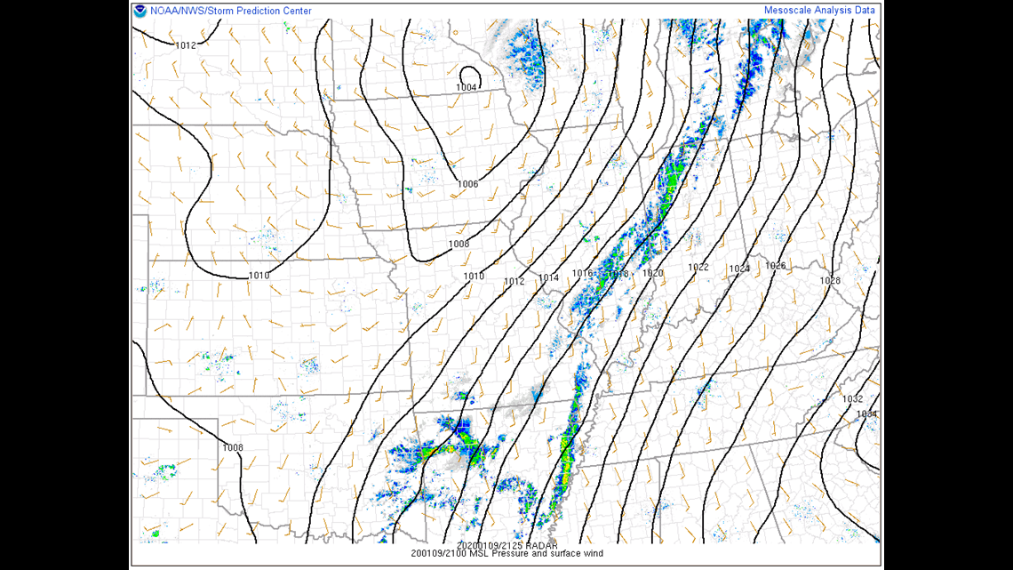
Thursday afternoon there was a storm system in the Midwest which was the primary source of our increased cloud cover. It was also producing some showers in Illinois which were weakening and moving into central Indiana. It also drew a warm front north over our region helping to bring in much warmer air as well as breezy conditions. Notice the isobars, those thin black lines all over the map. Those tell us what the atmospheric pressure level are at that location, and the closer together they are, the windier it’ll be (Figure 1). We’ll see breezy weather Friday and Saturday with sustained south winds around 15-20 mph with gusts over 40 mph not out of the question. We’ll discuss winds later.

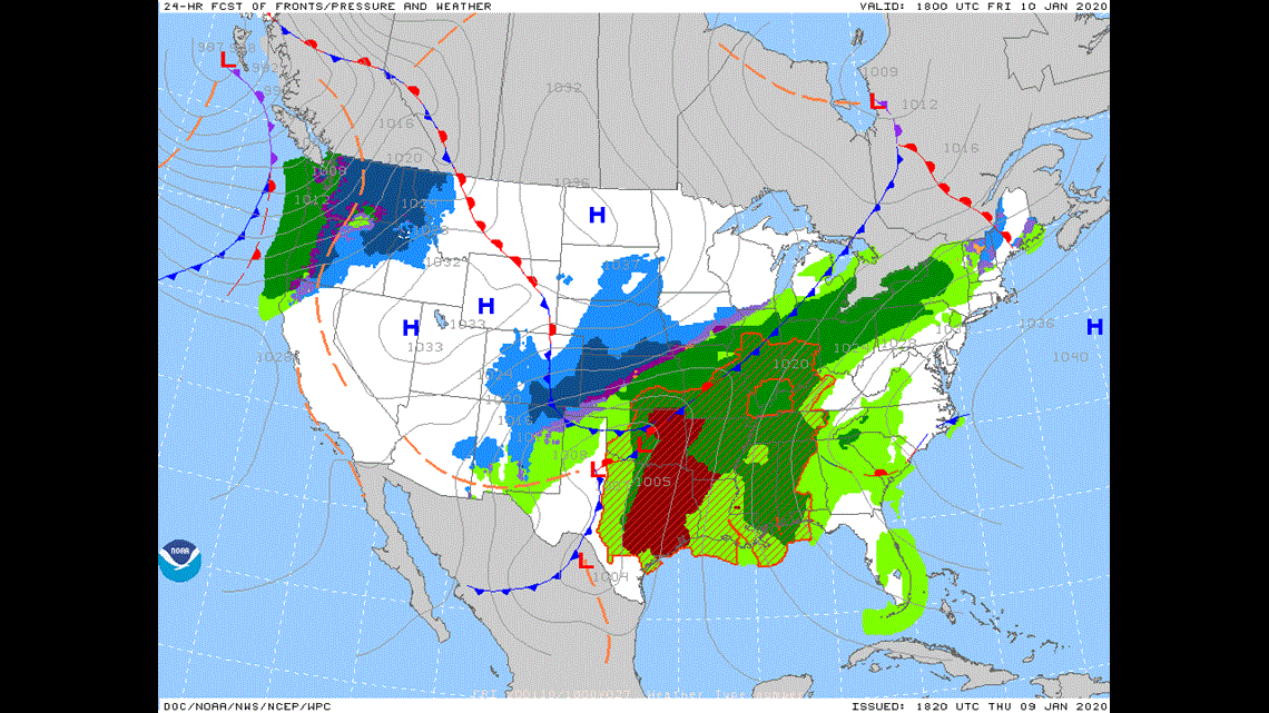
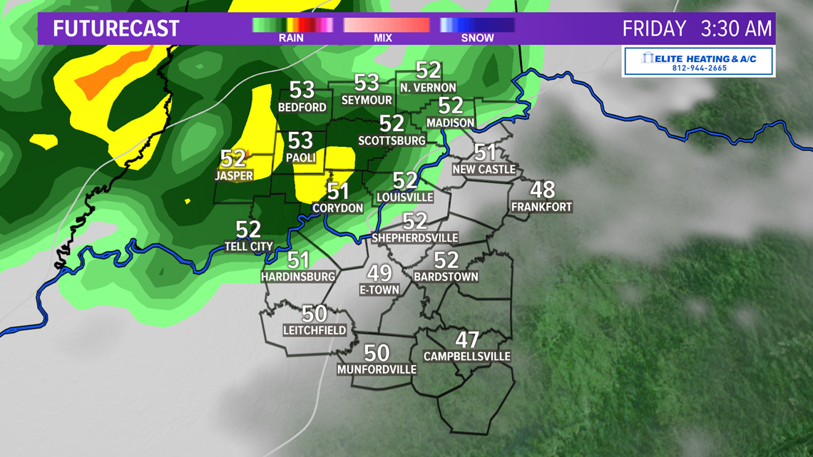
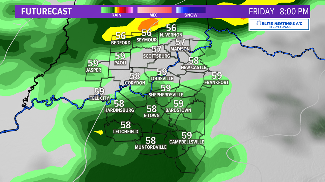
The storm we’ve been talking about since last week is still well to our west in the Rocky Mountains but will soon form into another very strong cyclone by Friday (Figure 2) and bring severe weather to parts of east Texas. As this storm moves from north and east Texas into the Midwest, chunks of energy will be ejected out ahead of us bringing our initial rounds of rain; the first round should arrive very late Thursday/early Friday morning, but mainly in southern Indiana as a cold front slowly approaches the area (Figure 3).


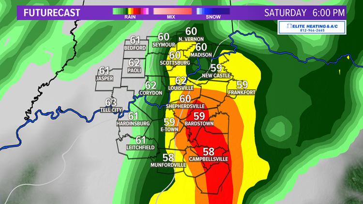
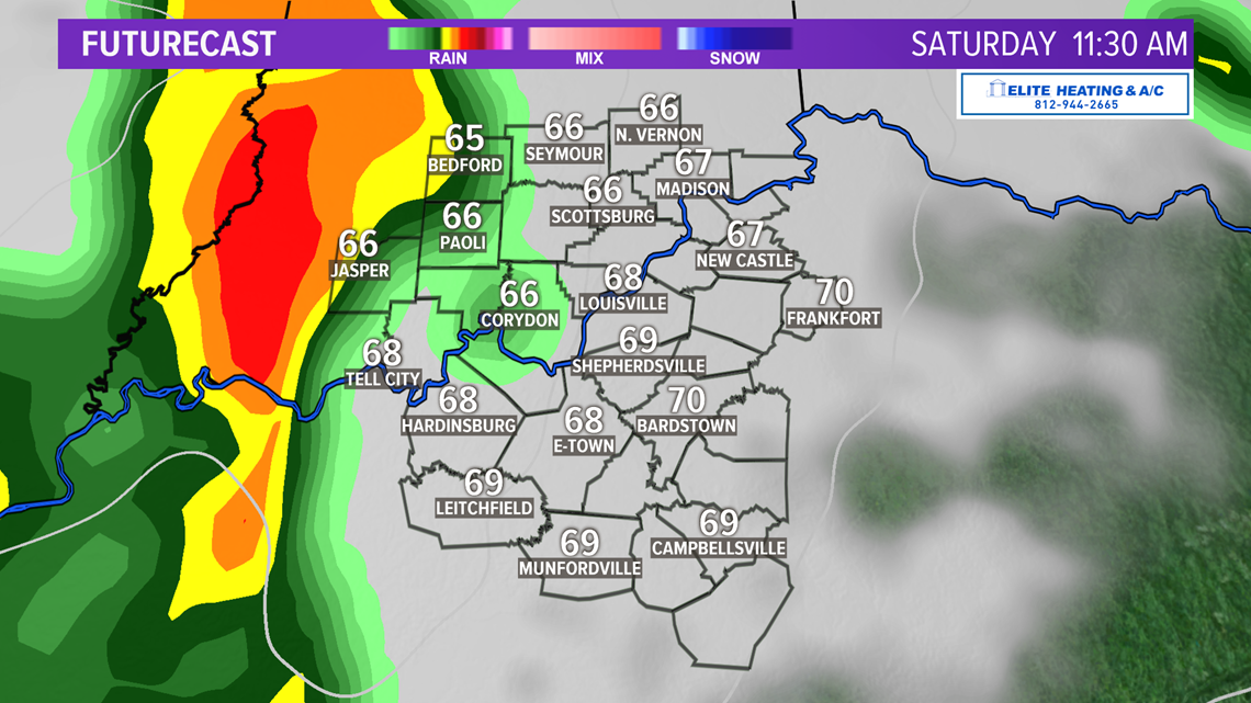
Rain will increase in coverage Friday afternoon to include more of central and southern Kentucky and continue in various pockets through the night. We can expect a brief break in the rain activity early Saturday ahead of a powerful cold front that will bring heavy rain and strong storms (Figures 4-5).


Will we see severe weather? There is a potential for severe weather Saturday afternoon across Kentucky. Our main severe weather threats are heavy rain potentially resulting in flash flooding, and high damaging wind gusts. The timing of this would be early-to-late Saturday afternoon as the cold front moves across the region. It should exit the region in the early evening hours and then the sky will calm down significantly (Figure 6).


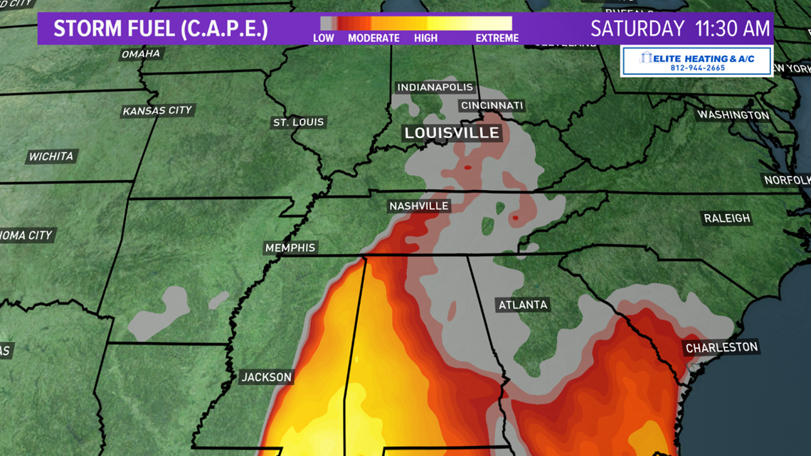
A few variables that make this forecast challenging are cloud cover, temperatures, and moisture. With temps in the upper 60s to low 70s across the area, there will a good amount of fuel for any potential storms. A strong cold front will be moving east during that team and will help to initiate some of those stronger storms. However, if clouds stick around all day that will limit daytime heating and thus lower the fuel source. Any break in cloud cover would allow for the surface to heat and increase instability in the atmosphere.
One way meteorologists determine how much energy is in the atmosphere is through a parameter called CAPE which is sort for Convective Available Potential Energy. Higher CAPE means more energy which is more fuel for any potential storms that develop. Just because CAPE is high doesn't mean severe weather will happen. Checking out how much energy is expected Saturday, we see that Kentucky is on the northern edge of a denser pool of CAPE in the Deep South (Figure 7).

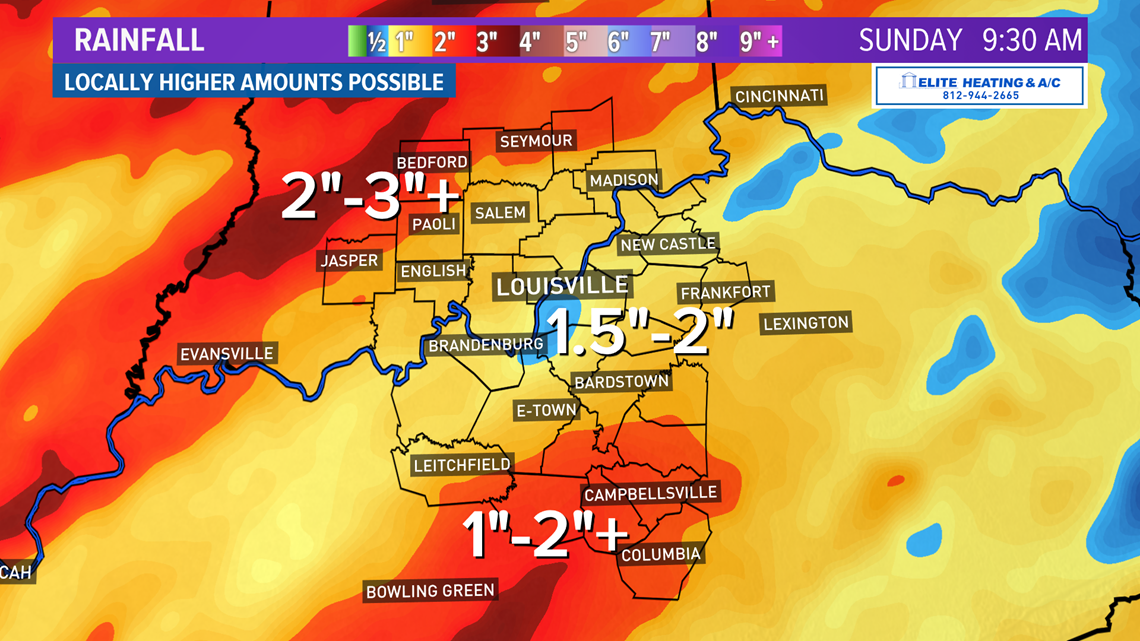
How much rain? There has been a northward trend in the models with the track of the storm, as well as a slower progression. That northward track would take the heaviest core of rain more into east/west central Illinois/Indiana respectfully. Even with that shift, everyone from southern Indiana to southern Kentucky should see respectable rain amounts.
Within our viewing area, south Indiana may see up to 3” of rain once everything ends by Sunday morning. While there are currently (as of Thursday afternoon) no early flood alerts in the coverage area, that could still change as we near the event. If stronger thunderstorms develop in central Kentucky Saturday afternoon, then isolated areas may also see rain totals exceeding two inches. Torrential downpours or steady rain over several hours may result in areas of flooding or flash flooding.

Where’s winter? With temperatures near 70 degrees Saturday it seems like winter 2019-2020 isn’t ever going to happen. Well, remember, it hasn’t even been winter for a full month yet. Looking at the long term model data, there are signs that we could see a return of much colder air late next week. Arctic air has been held up in Canada for several weeks (where temps have been as cold as 40° below zero) due to a variety of factors. That air may finally break free and bring much cooler air to the region by next weekend. We’ll see how that progresses in the coming days.
Meteorologist Alden German
Facebook: Facebook.com/AldenGermanWX | Twitter: @WXAlden