

LOUISVILLE, Ky. — We often talk about the dew point and humidity during our forecasts for the Commonwealth and Southern Indiana. Both humidity and dew point values have a major effect on our forecast, but they are very different.
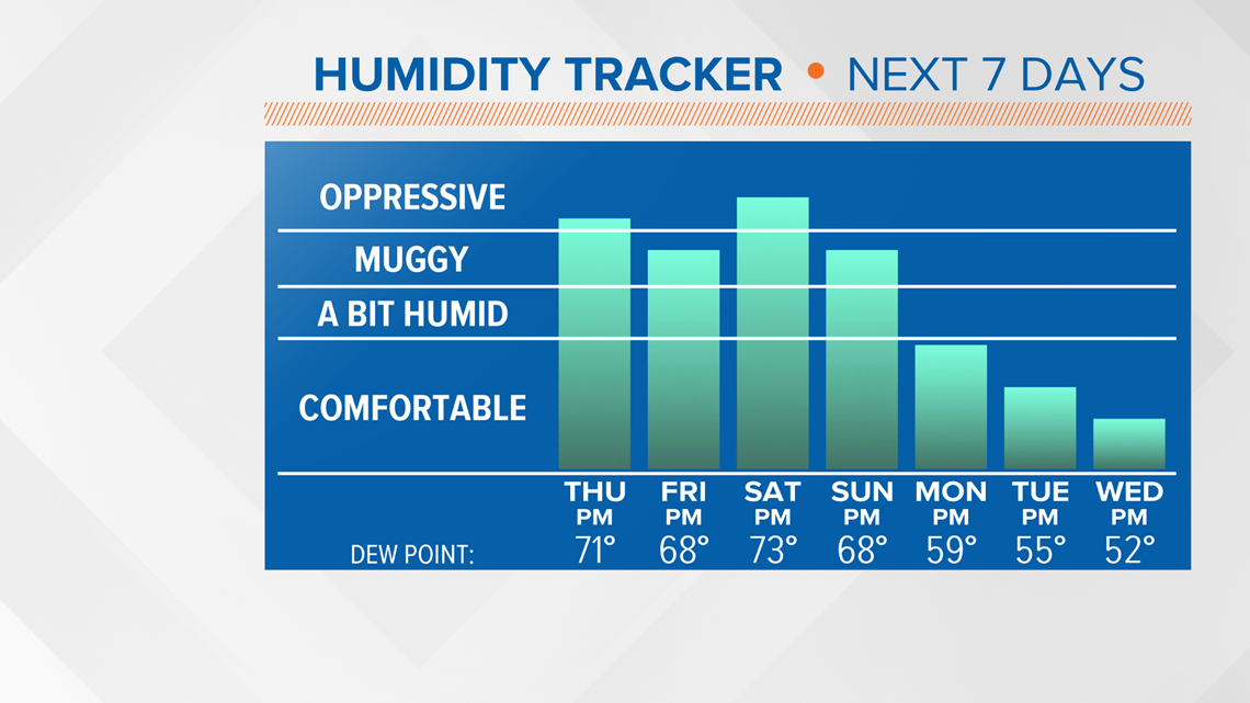
When dry air moves into the Ohio Valley, our dew point values trend lower and that often leads to some very comfortable weather! We have been stuck in a very muggy weather pattern for this second week of August, but some changes are not far away!

Humidity is the amount of water vapor in the air. We show you humidity values as a percentage during our forecasts. The reason we show that is because the number for each day tells us how close we are to the air being fully saturated. At full saturation, the air can condense into liquid water droplets.

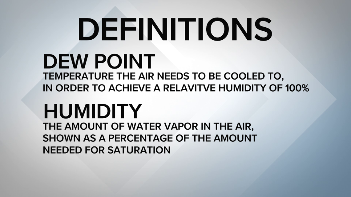
Dew point is actually a temperature! The definition of dew point is the temperature the air needs to be cooled to in order to achieve a relative humidity of 100%.
What that means is, the lower the dew point, the drier our air feels. Higher dew point values mean our air can feel muggy and sticky. We jokingly call it "air you can wear" because of how heavy and moist it can feel!

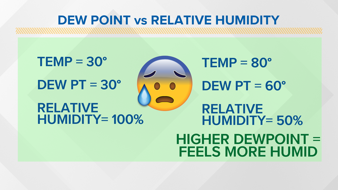
Now here's a little quiz... On day one, we have a temperature of 30 degrees and a dew point of 30 degrees. That allows our relative humidity to reach 100 percent. Now on day two, we have a temperature of 80 degrees and a dew point of 60 degrees, but our relative humidity is only 50 percent. Which day will feel more humid? The day with 100% or 50%?
It is actually the day with 50% humidity because our dew point - the measure of moisture in the air - is HIGHER.

Our dew points can drop for a variety of reasons, but one of the most common causes in an influx of drier air typically from the north. Cold fronts can sometimes move into the Ohio Valley and while the air along the front can still have higher dew points, the air behind a front tends to be drier. Cold fronts can also spark thunderstorms in Kentuckiana, but once the front clears our area, drier and less humid weather tends to follow!

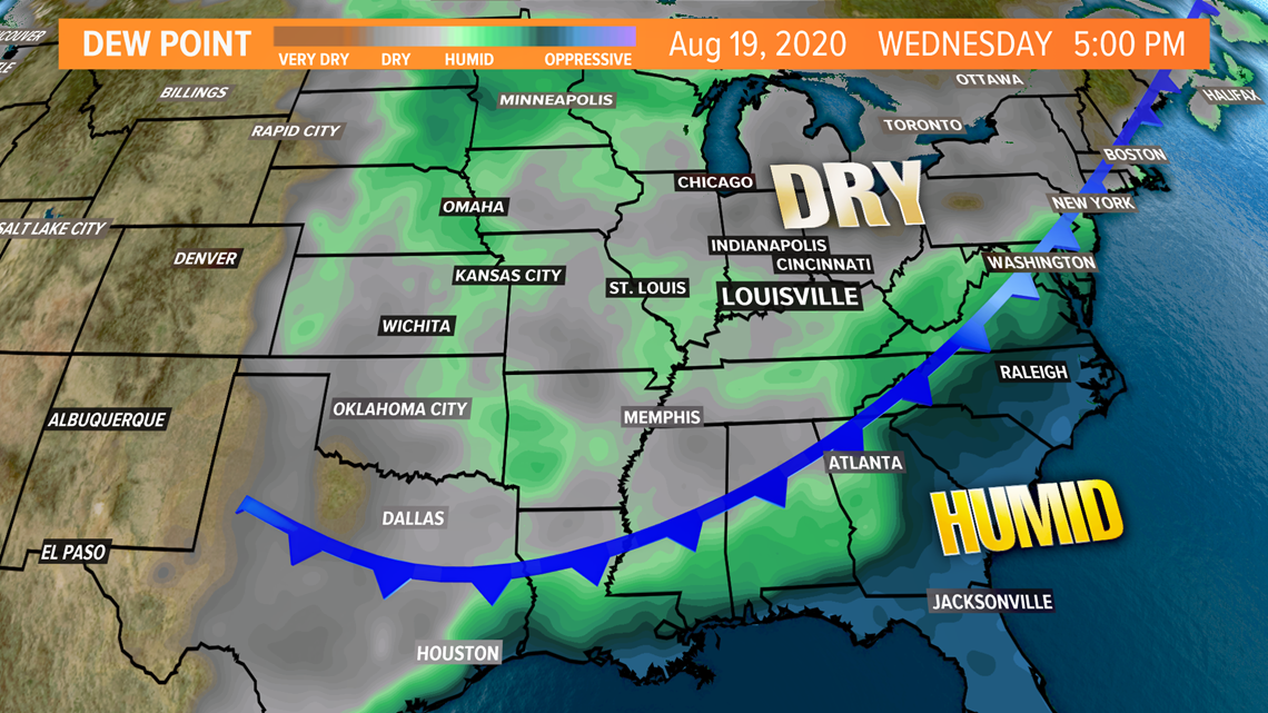
As we mentioned earlier in this blog, our weather pattern will be changing soon. We'll go from very high dew point values this week to lower values next week. This means our muggy, sticky days are short-lived! A cold front will move in by the end of the weekend and our dew point values will drop behind that front. Monday will be a bit of a transition day with slightly humid air still in place, but by next Tuesday drier air prevails and we'll be feeling great!


Make it easy to keep up-to-date with more stories like this. Download the WHAS11 News app now. For Apple or Android users.
Or, if you love weather photography, join our Kentucky/Indiana Cloud Watchers Facebook group.
--
Follow the WHAS11 First Alert Storm Team on Social Media:
Chief Meteorologist Ben Pine:
Facebook: Facebook.com/MeteorologistBenPine | Twitter: @WHAS11Ben | Instagram: @whas11pine
Meteorologist T.G. Shuck
Facebook: Facebook.com/tgshuck | Twitter: @TGweather
Meteorologist Kaitlynn Fish
Facebook: Facebook.com/WXkaitlynnfish | Twitter: @kaitlynnfish | Instagram: @kaitlynnfishwx
Meteorologist Reed Yadon
Facebook: Facebook.com/reedyadon | Twitter: @whas11reed
Meteorologist Alden German
Facebook: Facebook.com/AldenGermanWX | Twitter: @WXAlden