LOUISVILLE, Ky. — Remnants of Tropical Storm Helene will make their way north Thursday night into Friday, and many areas of Kentucky and Indiana will be impacted.
The National Weather Service has issued several watches, warnings and advisories in both states. In Louisville, heavy rain and strong winds will be the biggest impacts.
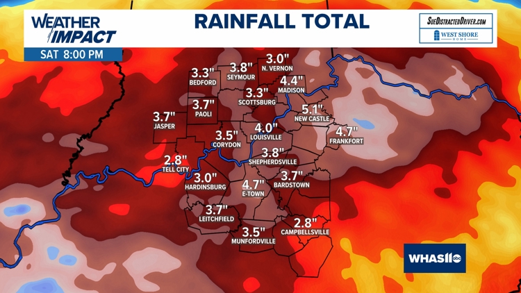
Between two and four inches of rain is expected. Flooding will be possible in certain areas.
Here are the current alerts from the National Weather Service:
Wind advisory
The following counties are under a wind advisory until 2 a.m. Saturday:
Kentucky: Perry, Hancock, Breckinridge, Meade, Ohio, Grayson, Hardin, Larue, Butler, Edmonson, Hart, Green, Logan, Warren, Simpson, Allen, Barren, Monroe, Metcalfe, Cumberland, Clinton
Flood watch
The following counties are under a flood watch until Saturday morning:
Kentucky: Perry, Meade, Bullitt, Spencer, Anderson, Woodford, Fayette, Clark, Hancock, Breckinridge, Ohio, Grayson, Hardin, Nelson, Washington, Mercer, Jessamine, Larue, Marion, Boyle, Garrard, Madison, Butler, Edmonson, Hart, Green, Taylor, Casey, Lincoln, Logan, Warren, Simpson, Allen, Barren, Monroe, Metcalfe, Adair, Russell, Cumberland, Clinton
High wind warning
The following counties are under a high wind warning until 11 p.m. Friday:
Indiana: Jackson, Jennings and Lawrence Counties
Kentucky: Carrol County
What to expect in Louisville area
With the wet ground, sometimes trees can topple over a bit easier, so spotty power outages will be possible. We'll also need to be extra attentive while driving, not only because of the ponding of water on the roads, but also the strong sustained winds.
Rainfall totals between 2 and 4 inches are possible, along and south of the Bluegrass and Western Kentucky parkways. Flooding will be possible in other areas as well, and watch for rising rivers, creeks and streams all weekend.
Keep an eye out for ponding of water on the roadways.


